


| Technical Name | Satellite Remote Sensing of Aerosol Profile in 3D PM2.5 Construction for Regional Air Pollution Monitoring | ||
|---|---|---|---|
| Project Operator | National Central University | ||
| Project Host | 林唐煌 | ||
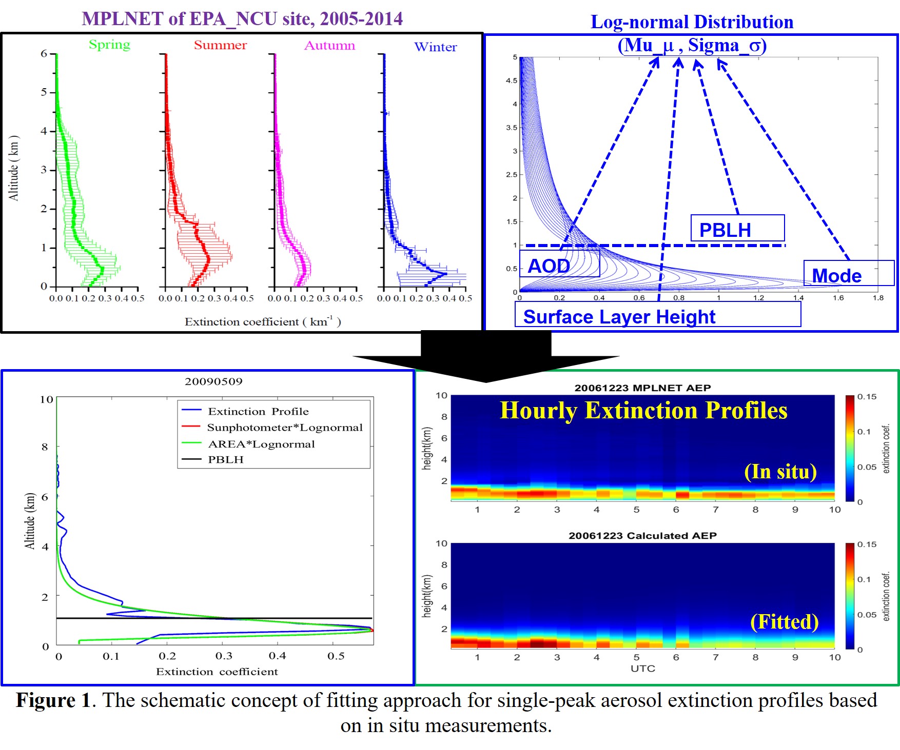
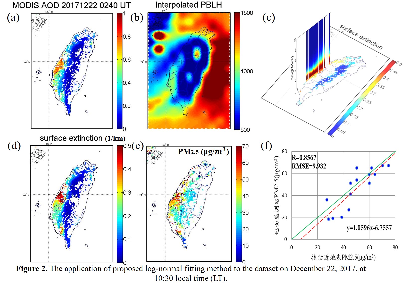
| Summary | Concerning the uncertainty of assuming well-mixed aerosols within the planetary boundary layer, a sensible aerosol vertical distribution described by a log-normal fitting function is proposed to provide more realistic single-peak extinction profile with a decadal MPL in situ dataset. The performance of fitted single-peak aerosol profiles can reach up 0.8973 of correlation coefficient when considering the seasonal variations in PBLH and the surface layer height of well-mixed aerosols. Eventually, not only the aerosol extinction profile but also the 3-dimensional distribution are promising to be created from satellite AOD retrieval with PBLH information for providing accurate PM2.5 monitoring over a regional scale. |
||
| Technical Film |
|
||
| Scientific Breakthrough | In terms of the planetary boundary layer height (PBLH)the total column aerosol optical depth (AOD), the single-peak aerosol profiles can be well described by the proposed log-normal distribution model with the following breakthrough, 1. New satellite retrievals in aerosol extinction profile 2. Enable satellite observation to prov 3D aerosol distribution (from columnar 2D) 3. Improve satellite remote sensing of surface PM2.5 with high temporal observation every 20 minutes 4.Overcome the international limitation in constructing 3D PM2.5 initial for modeling air pollution forecast. |
||
| Industrial Applicability | The proposed model for single-peak aerosol profile fitting will facilitate the advantages for industrial application as the followings. 1. Associated with multiple satellite observations, the unique 3D aerosol distribution highly increases industrial competitive capability internationally 2. Very practical with high performance and low cost for operational 3. The near real-time air pollution monitoring is enable to a large scale which well qualified for the warming of public health issues 4. User friendly 5. The technology can be applied in environmental protection agencies, weather industrial (e.g., Weather Risk Explore Inc.) or satellite image processing companies, including National Space Organization, SpaceX, Chung Hsing Surveying, LIDAR Technology, Spot Image in France, etc. |
||
| Keyword | Satellite Remote Sensing 3D Particulate Matters (PM2.5) Aerosol Profile Log-normal distribution Aerosol Optical Depth Planetary Boundary Layer High Spatiotemporal Observation Near Real-Time Air Quality Monitor Numerical Air Quality Forecast Public Health | ||
| Download |
Aerosol Profile Fitting_remotesensing_2020-Lin et al.pdf |
||
- thlin@csrsr.ncu.edu.tw
other people also saw